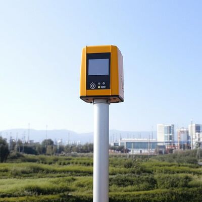
|
제품 상세 정보:
결제 및 배송 조건:
|
| Size: | 756mm*735mm*1000mm | Sight Detection Distance: | 10km |
|---|---|---|---|
| Maximum Acquisition Distance: | 15km | Distance Resolution: | 15m/30m/75m/120m |
| Sight Wind Speed Accuracy: | 0.1m/s | Weight: | ≤100kg |
| Pointing Acuracy: | ±0.005° | DataStorage Time: | 5to18months |
| 강조하다: | Doppler Wind Lidar remote data collection,Doppler Wind Lidar 4km measuring distance,Doppler Wind Lidar industrial vertical range |
||
Molas 3D is an advanced Doppler wind measurement lidar that operates using three-dimensional scanning technology. It utilizes the principle of pulsed laser coherent Doppler frequency shift to accurately capture wind speed data.
This innovative device supports multiple scanning modes, including P-Pl, RHI, DBS, and program scanning. Such versatility allows it to be tailored for specific wind speed measurement requirements across various applications.
The Molas 3D lidar is well-suited for a wide range of customized scenarios. These include offshore wind resource assessment, research in complex terrains, wind turbine wake detection, and airport glide path wind shear warnings. Additionally, it is valuable for urban meteorological observations and detecting high-altitude turbulence.
The system offers detailed measurement information by utilizing a refined 3D wind field measurement technique. It supports up to 300 customizable distance layers, allowing for precise and tailored data acquisition.
Equipped with a large detection range, the device can monitor sight distances up to 10 kilometers, particularly effective at altitudes below 600 meters.
This technology ensures exceptional precision, featuring a pointing accuracy of 0.005 degrees and a visual direction wind speed accuracy of 0.1 meters per second.
Multiple scanning techniques are supported, including PPl, RHl, DBS, and a programmable arbitrary scan method, allowing for versatile operational modes based on varying measurement needs.
Designed to be small and lightweight, the system facilitates easy transportation and rapid deployment in different environments.
Built to withstand harsh outdoor environments, it offers survivability in LPz0 and features lightning protection zones, ensuring reliable operation regardless of weather conditions.
Safety is paramount, with integrated GPS location reporting and geo-fencing capabilities. Additionally, data encryption safeguards against any risk of information leakage.
Users can select from four distance resolutions and five accumulation times, providing flexibility to tailor the system’s operation to specific requirements.
| Vertical Range | -10~190° |
| Sight Detection Distance | 10 km |
| Sight Wind Speed Range | -75~+75 m/s |
| Distance Resolution | 15 m / 30 m / 75 m / 120 m |
| Sight Wind Speed Accuracy | 0.1 m/s |
| Distance Layers | Up to 300 |
| Pointing Accuracy | ±0.005° |
| Accumulation Time | 0.2~10 s (Optional) |
| Data Storage Time | 5 to 18 months |
| Vertical Measuring Distance | 4 km |
Wind resource assessment involves collecting wind field data over extensive areas, which helps to minimize the risks associated with site selection for wind energy projects. By accurately measuring wind parameters, it ensures better planning and utilization of wind resources.
Long-distance power curve measurements and wake eddy current assessments play a significant role in optimizing wind energy utilization. These measurements contribute to improving the efficiency of wind energy units by providing detailed insights into wind flow dynamics and turbine performance.
Early detection and warning systems are essential for identifying dangerous meteorological phenomena, such as wind shear and microbursts. Timely warnings can enhance safety measures in aviation and other weather-sensitive operations.
Measuring wake vortices is crucial for optimizing flight separation at airports. By understanding these vortices, air traffic controllers can better manage aircraft spacing, thereby increasing airport traffic efficiency and safety.
Providing detailed wind field information aids in understanding the behavior of wind within the atmospheric boundary layer. This data is vital for meteorological studies and improving weather forecasting models.
Accurate and high spatiotemporal wind profile measurements near the surface, within a few kilometers, help fill the observation gaps at low altitudes. This enhanced data resolution supports various applications ranging from environmental monitoring to renewable energy development.
Real-time three-dimensional information about plume dispersion enables effective tracking of emission sources. Such monitoring is particularly valuable for environmental management and controlling air pollution.
Additionally, optimizing dust emission control in the mining industry relies on precise wind and dispersion measurements. These techniques help minimize environmental impacts and enhance operational safety in mining activities.
담당자: Miss. ivyyao
전화 번호: +86 13072523225
팩스: 86-025-86800073